[ad_1]

As the Environment Agency together with Somerset County Council declares a ‘major incident’ on the vulnerable Somerset Levels, Local Resilience Forums (LRFs) up and down the country continue to maintain a cautious watch in anticipation of further flood warnings.
Current concerns are centred around the Southwest and along the South coast, where higher-than-average rainfall has been recorded each month since the end of last Summer. Southern Water reported that rainfall had been 44% higher than the long-term average in December after a staggering 155% increase during November, and this has shown little sign of abating through the remaining winter months.
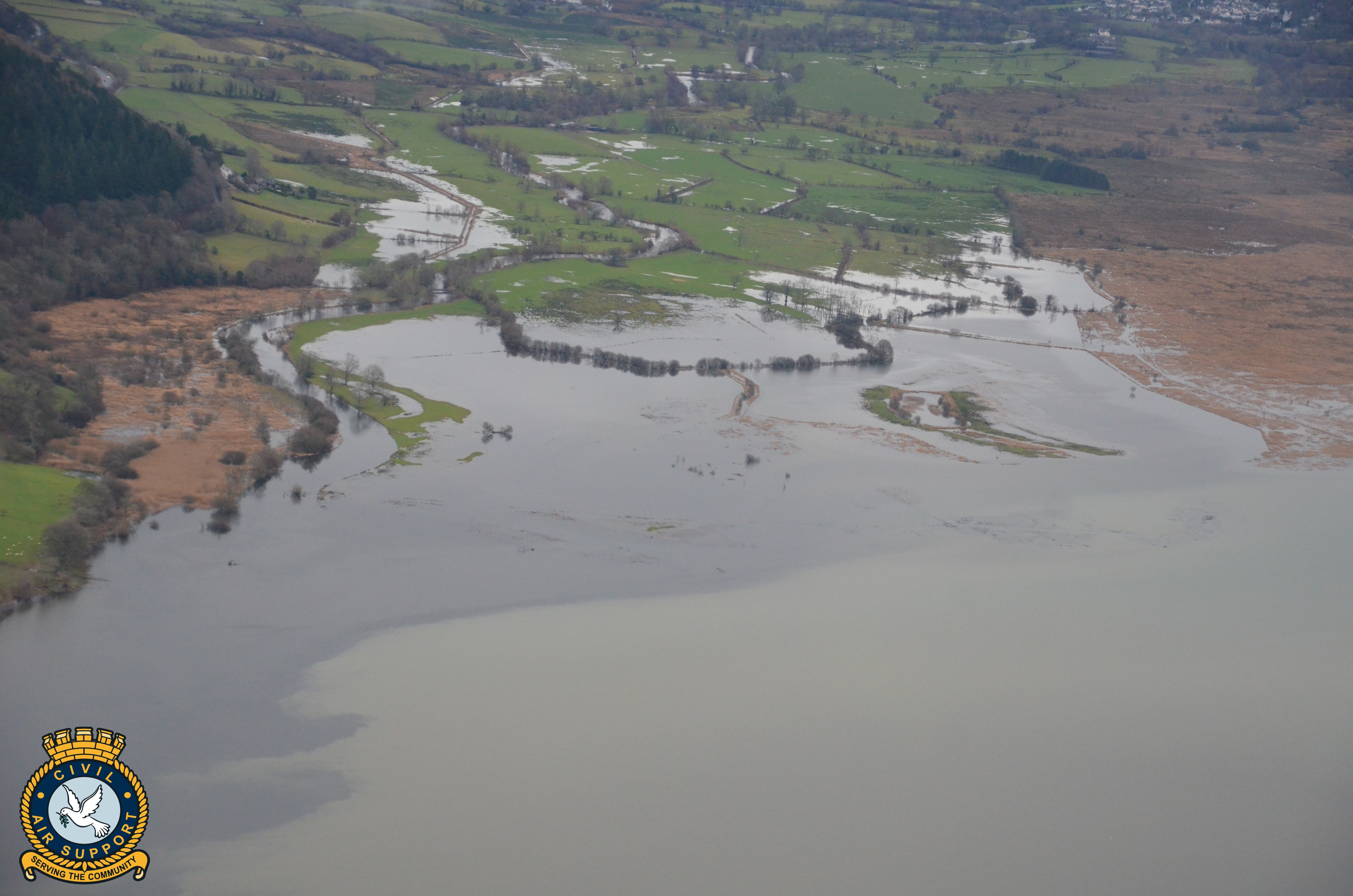
Flood risks are not limited to Southern regions however, and Civil Air Support photographic missions have observed extensive flooding across the country including the Midlands, Cumbria, and the far North.
Having already captured a significant volume of high-resolution images that reveal the extent of flood damage together with the potential threat to transportation systems, property and livestock from rising water levels, the charity’s pilots and aircraft are standing by to offer further assistance to LRFs across the UK.
The benefits of using Civil Air Support (CAS) aircraft for this kind of activity are many. Detailed image capture of affected areas requires expensive photographic equipment, trained crews and high-wing aircraft that are capable of controlled slow flight. The cost to deploy Emergency Services aircraft would be prohibitive for this kind of observational flying, and CAS services are offered to Local Authorities and LRFs free of charge. The topographical perspective provided by CAS crews can be a rich source of intelligence to those responsible for developing and executing a multi-agency planned response to flooding.
A recent observation mission saw an Ikarus C42 high-wing microlight aircraft piloted by CAS Operations Manager Niall Paterson cover areas of Southwest Scotland and Cumbria where flood warning alerts had been issued. During the mission flight which lasted approximately 1 hour 52 minutes, experienced CAS observer Adrian Johnson captured images of roads and urbanisations at a high risk of flooding. The photographs included here show flooding around Bassenthwaite Lake, Dumfries and Keswick.
Commenting on the mission, pilot Niall Paterson reports that the threat to public safety, property and livestock is significant.
“After recording the impact of high water levels in Dumfries, we diverted from our planned routing in response to an alert of flooding around Keswick. We were able to capture images that illustrated not only the extent of the flooding, but also the locations which appeared to be most at risk”.
The Ikarus flight clearly demonstrates the capability of CAS crews and aircraft in these circumstances, enabling the capture of intelligence at multiple locations where access via surface transportation would be difficult. Niall continues…
“We completed the capture of the Dumfries images at 12:06 and then flew South East via Carlisle (where there was no flooding) arriving overhead Bassenthwaite Lake at 12:42”.
Flood water reconnaissance missions can provide LRFs and emergency planners with real-time information to assist responders, but also critical intelligence to aid future planning in response to the freak weather conditions that appear to be more commonplace in our increasingly unpredictable climate.
ENDS
About Civil Air Support (CAS) https://www.civilairsupport.com/
Charity registered in England and Wales (1113079) and Scotland (SCO42026)
Civil Air Support is the largest charitable air support organisation in Europe with around 200 members, together with a fleet of privately-owned aircraft. All Civil Air Support members are volunteers, and all flights are private. The primary mission of Civil Air Support is to provide voluntary air support to safeguard communities and the environment. Civil Air Support will only operate when the alternative is no air support at all. Civil Air Support assistance sorties are provided free of charge.
About Local resilience forums (LRFs)
Local resilience forums (LRFs) are multi-agency partnerships made up of representatives from local public services, including the emergency services, local authorities, the NHS, the Environment Agency and others. These agencies are known as Category 1 Responders, as defined by the Civil Contingencies Act.
LRFs are supported by organisations, known as Category 2 responders, such as the Highways Agency and public utility companies. They have a responsibility to co-operate with Category 1 organisations and to share relevant information with the LRF. The geographical area the forums cover is based on police areas.
LRFs also work with other partners in the military and voluntary sectors who provide a valuable contribution to LRF work in emergency preparedness.
The LRFs aim to plan and prepare for localised incidents and catastrophic emergencies. They work to identify potential risks and produce emergency plans to either prevent or mitigate the impact of any incident on their local communities.
Enquiries/Further Information:
Will Ingleby, Media Officer, Civil Air Support
[email protected] m. 07976 853378
[ad_2]
Source link


